
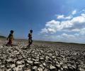
Heavy overnight rains severely affected parts of the city on Monday, leading to water-logged roads, inundated residential areas and traffic pile-up, as the city braces for more spells in the coming days.

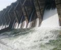
Three gates of the Middle Vaitarna Dam in Palghar district were opened on Monday afternoon following a sharp rise in water levels due to continuous rainfall in the catchment area.

It is in more than a decade that the IMD has predicted 'above-normal' rains in the country.

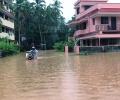
Intense rains lashed Kerala on Sunday, uprooting trees across the state, including one that fell on a moving train in Thrissur and another that caused a fatality in Kozhikode. Houses were damaged, rivers were in spate, and shutters of some dams were raised as the southwest monsoon gained strength. The Indian Meteorological Department (IMD) placed five northern districts - Malappuram, Kozhikode, Wayanad, Kannur, and Kasaragod - under a 'red alert' for the day, predicting extremely heavy rainfall there.

India is likely to see above-normal maximum and minimum temperatures in most parts of the country in the March to May period, IMD director general Mrutyunjay Mohapatra said at a press conference.

Thane and Palghar districts in India experienced heavy rainfall, leading to road closures and the evacuation of residents from vulnerable areas. The rising water levels of the Ulhas River prompted authorities to close the Raite bridge on the Kalyan-Murbad road, diverting traffic via Titwala. In Ambernath, 50 residents were evacuated from Swabhiman Chali near the Ulhas river. Waterlogging was reported in low-lying areas of Kulgaon-Badlapur. Officials are monitoring the situation closely and urging timely reporting of incidents.

Rainfall in August is predicted to be below normal (less than 94 per cent of LPA), but the situation is expected to improve comparatively in September, the IMD said.

Addressing a press conference virtually, India Meteorological Department Director General Mrutyunjay Mohapatra said September was likely to witness normal rainfall in the range of 91-109 per cent of the long period average of 167.9 mm.
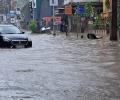
Heavy monsoon rains battered Karnataka's coastal belt for the third consecutive day on Monday, severely disrupting normal life in Dakshina Kannada district, prompting authorities to issue a red alert and deploy disaster response teams. A red alert indicates extremely heavy rainfall of over 20 cm in 24 hours, and will remain in force for the next five days, according to the India Meteorological Department (IMD). Several parts of Mangaluru city reported waterlogging and traffic snarls, while minor incidents of landslides were reported from hilly regions across the district. The district administration has directed schools and composite colleges to remain shut on 27 and 28 following the IMD issuing a red alert. Instructions were also issued to relocate residents living in vulnerable hillside and riverside areas to safer locations. The authorities have sought prompt action from the National Highways Authority of India (NHAI) following complaints of water intrusion in residential areas due to ongoing highway construction works.

India's power sector CO2 emissions fell in H1 2025 for the first time in nearly 50 years (outside the pandemic), thanks to record renewable growth and lower coal use from cooler, wetter weather.

Glimpses from India and around the world that will make you smile and cry.

This was a soaring evening that sent hearts aflutter and for a few brief moments we tasted the breath of pure freedom that has been missing in this country for the past several years.

Several deaths were reported across the country due to rain-related incidents like lightning strikes and drowning.

Five people died in rain-related incidents in Delhi Friday as Monsoon arrived with a fury early in the morning, lashing the city with its highest rainfall in a single day of June in 88 years which brought it to a standstill with streets flooded, traffic in chaos and some commuters stranded on roads.

After being pummelled by heavy downpours at the start of the week, Mumbai witnessed a brief respite on Tuesday morning, with the island city recording an average rainfall of 106 mm in 24 hours, civic officials said.

In addition to that, 68 people still remain missing, with 100 more sustaining injuries in the disaster.

The rains after arriving over Kerala will quickly cover Tamil Nadu and Karnataka, but then might slacken a bit, which could delay its arrival over Northwest India.

Houses in low lying areas of Kerala were flooded in the heavy rains, while the accompanying strong winds uprooted trees, damaged homes and caused power disruptions, throwing normal way of life into disarray across the state.

Because the ecology of various regions differs, it is silly to club them all under one countrywide average number, says Nitin Sethi.

Skymet said the monsoon this year could be 100 per cent of the long period average (LPA) with a model error of plus and minus 5 per cent.

The India meteorological department said heatwave conditions will persist for at least two more days.
The IMD issued a "Nowcast" warning, forecasting thunderstorms accompanied by lightning and intense spells of rain with gusty winds reaching 50-60 kmph at isolated places in Mumbai in the next three to four hours.

As many as 12 flights were diverted at the Delhi airport between 3 pm and 4 pm due to adverse weather conditions, an official said.

The IMD defines a normal monsoon as one which delivers between 96 and 104 per cent of the 50-year average rainfall for the season.

Scientists had earlier said the cyclone pulled the moisture and convection, impacting the intensity of the monsoon and delaying its onset over Kerala.

Heavy rains and landslides in Himachal Pradesh have resulted in multiple fatalities and widespread disruption, including road closures and train cancellations.

Chief Economic Advisor V Anantha Nageswaran on Thursday said economic activity in some sectors have picked up pace during October-November and a GDP growth of 6.5-7 per cent in the current fiscal is feasible.
South-west monsoon is likely to be below normal this season, government announced on Wednesday raising concerns about its impact on agriculture and economy.

Intermittent, widespread rains lashed Chennai and other regions of Tamil Nadu on Tuesday and the India meteorological department said the low pressure area over the Bay of Bengal has turned into a well-marked low pressure area and it is likely to become a depression.
'China could intentionally release excess water.' 'The North East is already flood-prone during the monsoon, and even a controlled release from Chinese dams (during the monsoon) could worsen flooding.'

'All El Ninos are not associated with the deficient monsoon.'
The government must prepare for below-normal monsoon.
Bringing in the much-needed respite from the hot and humid conditions, the monsoon arrived in Mumbai with heavy showers lashing the city Thursday night and Friday morning.
While it hit the national capital two days before schedule, its entry into the financial capital is two weeks late, the Met office said.
All parts except Northeast may get below-normal rain; govt reiterates assurance on preparations.
With monsoon rainfall 16% below the long-period average, total sowing area is down by 7% at 56.7 million hectares so far this season.
64 years after the Panshet Dam burst claimed 1,000 lives, the tragedy stands as both a haunting memory and a vital lesson in engineering caution.

Meteorologists earlier said Cyclone 'Biparjoy' had been impacting the intensity of the monsoon and that its onset over Kerala would be 'mild'.

The monsoon rains are crucial for farm output and economic growth as about 55 per cent of the south Asian nation's arable land is rain-fed.

Bhavnagar was also one of the worst affected districts, they said, adding that more downpour is likely over the next four day in parts of the state.